Example plotting following ASP Docs jitter_solve ASTER example for ASTER with Jitter Correction#
Below are example asp_plot outputs following the processing in the ASP Docs jitter_solve ASTER example.
Before exploring this example, be sure you can produce mapprojected outputs and DEMs with this notebook.
We diverge from the documentation example data, instead retrieving the example data used in https://github.com/uw-cryo/asp_tutorials:
Note on ASTER L1A data format change: In December 2025, NASA decommissioned the ASTER L1A Version 003 product (distributed as a
.zipof GeoTIFF images and text geometry files) and replaced it with Version 004 (distributed as a single HDF-EOS2.hdffile). The Zenodo archive below preserves the old V003 format. If you are downloading new ASTER data from NASA Earthdata, you will receive V004 HDF files instead. Both formats are supported byaster2asp(HDF support requires ASP build 2026-01-28 or later). See the aster2asp documentation for details.
Option A: V003 data from Zenodo (legacy format)
wget https://zenodo.org/record/7972223/files/AST_L1A_00307312017190728_20200218153629_19952.zip

mkdir dataDir

tar xvf AST_L1A_00307312017190728_20200218153629_19952.zip -C dataDir
Option B: V004 data from NASA Earthdata (current format)
Download an ASTER L1A .hdf file from NASA Earthdata.
Pre-process the images for stereo:
# For V003 directory input:
aster2asp dataDir -o out

# For V004 HDF input:
aster2asp input.hdf -o out
Both produce the same output:
out-Band3B.tif
out-Band3B.xml
out-Band3N.tif
out-Band3N.xml
We download Copernicus 30 m reference DEM data, using: https://github.com/uw-cryo/fetch_dem:
You will need to request your own OpenTopography API key to add to this command as the argument to
-apikey.You will also need the output of mapprojection from the previous notebook to use
out-Band3B_proj.tifas the extent argument to-raster_fn.
Once you have that prepared:
python download_global_DEM.py \
  -demtype COP30 \
  -raster_fn out-Band3B_proj.tif \
  -out_fn cop30.tif \
  -apikey [OPEN_TOPOGRAPHY_API_KEY]
Then adjust the vertical reference to attain a reference DEM relative to the WGS84 ellipsoid:
dem_geoid --geoid egm2008 --reverse-adjustment cop30.tif

mv cop30-adj.tif ref.tif
And then blur the reference dem per the docs with:
dem_mosaic --dem-blur-sigma 2 ref.tif -o ref_blur.tif
Run initial bundle adjustment:
bundle_adjust -t aster          \
  --aster-use-csm               \
  --camera-weight 0.0           \
  --tri-weight 0.1              \
  --tri-robust-threshold 0.1    \
  --num-iterations 50           \
  out-Band3N.tif out-Band3B.tif \
  out-Band3N.xml out-Band3B.xml \
  -o ba/run
Run mapprojection:
Note: The ASTER scene is from Mt. Rainier in Washington State, so the local stereographic projection uses (-121.7603, 46.8523) as the (lon, lat):
proj='+proj=stere +lat_0=46.8523 +lon_0=-121.7603 +k=1 +x_0=0 +y_0=0 +datum=WGS84 +units=m +no_defs'

mapproject -t csm                       \
 --tr 15 --t_srs "$proj"                \
  ref_blur.tif out-Band3N.tif           \
  ba/run-out-Band3N.adjusted_state.json \
  out-Band3N.map.tif

mapproject -t csm                       \
 --tr 15 --t_srs "$proj"                \
  ref_blur.tif out-Band3B.tif           \
  ba/run-out-Band3B.adjusted_state.json \
  out-Band3B.map.tif
Run stereo processing and DEM generation:
parallel_stereo                         \
  --stereo-algorithm asp_bm             \
  --subpixel-mode 1                     \
  --max-disp-spread 100                 \
  --num-matches-from-disparity 100000   \
  out-Band3N.map.tif out-Band3B.map.tif \
  ba/run-out-Band3N.adjusted_state.json \
  ba/run-out-Band3B.adjusted_state.json \
  stereo_bm/run                         \
  ref_blur.tif

point2dem --errorimage --t_srs "$proj" \
  --tr 15 stereo_bm/run-PC.tif         \
  --orthoimage stereo_bm/run-L.tif
The results of this first part are displayed below.
Result of stereo before correction for jitter#
Example plots showing the outputs prior to jitter correction.
directory = "~/Desktop/asp-plot-examples/aster_jitter/"
bundle_adjust_directory = "ba/"
stereo_directory = "stereo_bm/"
reference_dem = f"{directory}ref.tif"
Stereo Geometry Analysis#
It’s useful to analyze the stereo acquisition geometry to verify the convergence angle and other geometric properties. ASTER’s gen_aster camera files record no view-angle summary, so asp_plot derives the geometry by intersecting the per-pixel look vectors with the WGS84 ellipsoid — giving the nadir (3N) and backward (3B) footprints, satellite tracks, and the ~31° convergence angle of ASTER’s along-track stereo pair:
from asp_plot.stereo_geometry import StereoGeometryPlotter

sgp = StereoGeometryPlotter(directory)
scene_bounds = sgp.parser.get_scene_bounds()

print(f"Scene extent (lon/lat): {scene_bounds[0]:.6f} {scene_bounds[1]:.6f} "
      f"{scene_bounds[2]:.6f} {scene_bounds[3]:.6f}")

_ = sgp.stereo_geom_plot()
Scene extent (lon/lat): -122.487668 46.605163 -121.250955 47.499986

Processing Parameters#
%load_ext autoreload
%autoreload 2

from asp_plot.processing_parameters import ProcessingParameters
processing_parameters = ProcessingParameters(
    processing_directory=directory,
    bundle_adjust_directory=bundle_adjust_directory,
    stereo_directory=stereo_directory
)
processing_parameters_dict = processing_parameters.from_log_files()

print(f"Processed on: {processing_parameters_dict['processing_timestamp']}\n")

print(f"Reference DEM: {processing_parameters_dict['reference_dem']}\n")

print(f"Bundle adjustment ({processing_parameters_dict['bundle_adjust_run_time']}):\n")
print(processing_parameters_dict["bundle_adjust"])

print(f"\nStereo ({processing_parameters_dict['stereo_run_time']}):\n")
print(processing_parameters_dict["stereo"])

print(f"\nPoint2dem ({processing_parameters_dict['point2dem_run_time']}):\n")
print(processing_parameters_dict["point2dem"])
Processed on: 2025-11-17 15:41:15

Reference DEM: ref_blur.tif

Bundle adjustment (0 hours and 0 minutes):

bundle_adjust -t aster --aster-use-csm --camera-weight 0.0 --tri-weight 0.1 --tri-robust-threshold 0.1 --num-iterations 50 out-Band3N.tif out-Band3B.tif out-Band3N.xml out-Band3B.xml -o ba/run

Stereo (0 hours and 3 minutes):

stereo --stereo-algorithm asp_bm --subpixel-mode 1 --max-disp-spread 100 --num-matches-from-disparity 100000 out-Band3N.map.tif out-Band3B.map.tif ba/run-out-Band3N.adjusted_state.json ba/run-out-Band3B.adjusted_state.json stereo_bm/run ref_blur.tif --corr-seed-mode 1 --sgm-collar-size 0 --compute-point-cloud-center-only --threads 8

Point2dem (0 hours and 0 minutes):

point2dem --t_srs "+proj=stere +lat_0=46.8523 +lon_0=-121.7603 +k=1 +x_0=0 +y_0=0 +datum=WGS84 +units=m +no_defs" --tr 15 stereo_bm/run-align-trans_reference.tif
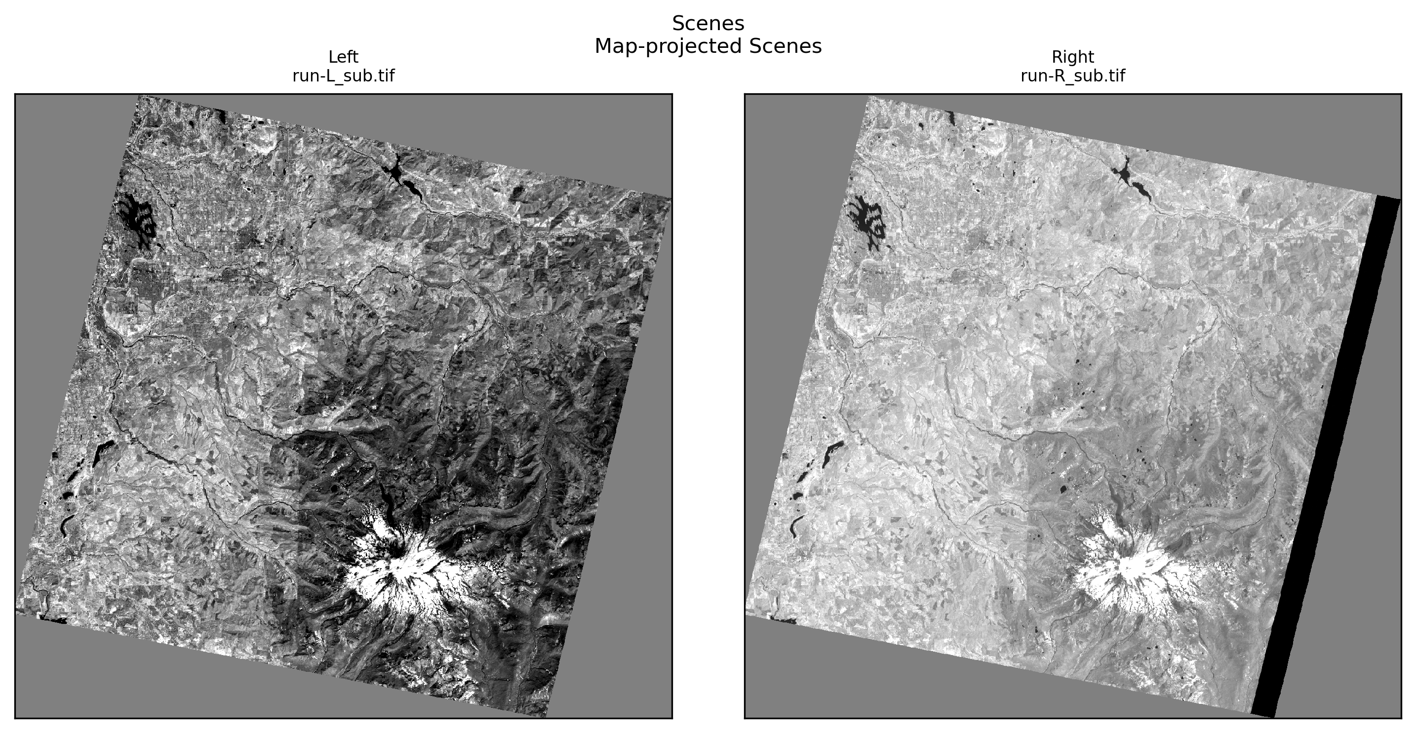
Scene Plots#
from asp_plot.scenes import ScenePlotter
plotter = ScenePlotter(
  directory,
  stereo_directory,
  title="Scenes"
)

plotter.plot_scenes()
[]
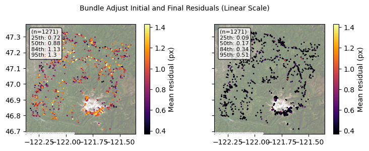
Bundle Adjustment Plots#
import contextily as ctx
from asp_plot.bundle_adjust import ReadBundleAdjustFiles, PlotBundleAdjustFiles
map_crs = "EPSG:4326"

ctx_kwargs = {
    "crs": map_crs,
    "source": ctx.providers.Esri.WorldImagery,
    "attribution_size": 0,
    "alpha": 0.5,
}
ba_files = ReadBundleAdjustFiles(directory, bundle_adjust_directory)
resid_initial_gdf, resid_final_gdf = ba_files.get_initial_final_residuals_gdfs(residuals_in_meters=True)
plotter = PlotBundleAdjustFiles(
  [resid_initial_gdf, resid_final_gdf],
  lognorm=False,
  title="Bundle Adjust Initial and Final Residuals (Linear Scale)"
)

plotter.plot_n_gdfs(
    column_name="mean_residual",
    cbar_label="Mean residual (px)",
    map_crs=map_crs,
    **ctx_kwargs
)
Camera Position and Orientation Changes#
ASTER’s L1A cameras start far from where they should be, and this figure — read from the ba/ folder alone (*.adjust, camera_offsets.txt, triangulation_offsets.txt; no original cameras needed) — shows how far bundle_adjust had to move them: the backward-looking Band3B camera by 8 m horizontally and 12 m vertically, the nadir Band3N camera by 286 m and 96 m, with rotations up to 0.016°. The triangulated points moved by a median of 0.6 m. As in the WorldView Atlanta example, a large center shift paired with a much smaller ground change means the solver traded camera position against orientation. Bundle adjustment fixes one rigid offset per camera; the jitter section below handles the line-by-line wobble that remains. The same figure is available from the bundle_adjust_cameras command-line tool and is a page of the asp_report PDF.
from asp_plot.bundle_adjust import ReadBundleAdjustCameras, PlotBundleAdjustCameras

cam_gdf = ReadBundleAdjustCameras(directory, bundle_adjust_directory).get_camera_optimization_gdf(
    map_crs=int(map_crs.split(":")[-1])
)
fig = PlotBundleAdjustCameras(cam_gdf, title="Camera changes from bundle_adjust (ASTER Band3N/3B)").summary_plot()

Stereo Plots#
from asp_plot.stereo import StereoPlotter
plotter = StereoPlotter(
  directory,
  stereo_directory,
  reference_dem=reference_dem,
)
WARNING:asp_plot.utils:Could not find ('*-align-L.txt',) in /Users/ben/Desktop/asp-plot-examples/aster_jitter/stereo_bm/. Some plots may be missing.
WARNING:asp_plot.utils:Could not find ('*-align-R.txt',) in /Users/ben/Desktop/asp-plot-examples/aster_jitter/stereo_bm/. Some plots may be missing.
Reference DEM: /Users/ben/Desktop/asp-plot-examples/aster_jitter/ref.tif


ASP DEM: /Users/ben/Desktop/asp-plot-examples/aster_jitter/stereo_bm/run-DEM.tif
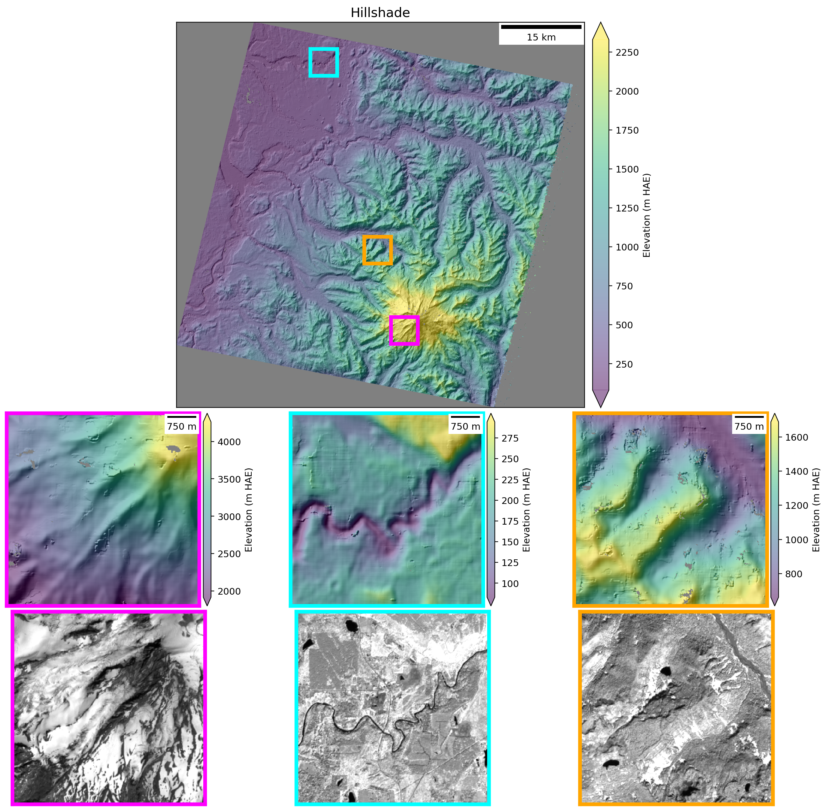
plotter.title = "Hillshade"

plotter.plot_detailed_hillshade(
  subset_km=5
)
plotter.title="Stereo Match Points"

plotter.plot_match_points()
[]

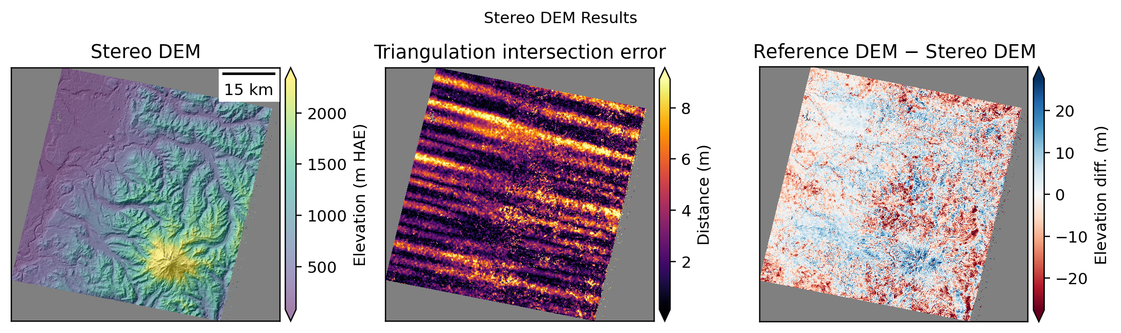
plotter.title = "Stereo DEM Results"

plotter.plot_dem_results()
Plotting DEM results. This can take a minute for large inputs.
WARNING:asp_plot.stereo:

Found a DEM of difference: /Users/ben/Desktop/asp-plot-examples/aster_jitter/stereo_bm/run-diff.tif.
Using that for difference map plotting.
Jitter Correction#
Following the initial stereo results, we continue with the ASP docs example commands:
Align the initial DEM to the COP30 reference and create the aligned DEM:
pc_align --max-displacement 50          \
  stereo_bm/run-DEM.tif ref.tif           \
  -o stereo_bm/run-align                  \
  --save-inv-transformed-reference-points

point2dem --t_srs "$proj" --tr 15 \
  stereo_bm/run-align-trans_reference.tif
Then take the difference:
geodiff stereo_bm/run-align-trans_reference-DEM.tif \
  ref.tif -o stereo_bm/run
Apply another bundle adjustment step:
bundle_adjust -t csm                        \
  --initial-transform                       \
  stereo_bm/run-align-inverse-transform.txt \
  --apply-initial-transform-only            \
  out-Band3N.map.tif out-Band3B.map.tif     \
  ba/run-out-Band3N.adjusted_state.json     \
  ba/run-out-Band3B.adjusted_state.json     \
  -o ba_align/run
Solve for jitter:
mkdir -p jitter

cp stereo_bm/run-disp-out-Band3N__out-Band3B.match \
  jitter/run-out-Band3N__out-Band3B.match

jitter_solve out-Band3N.tif out-Band3B.tif        \
  ba_align/run-run-out-Band3N.adjusted_state.json \
  ba_align/run-run-out-Band3B.adjusted_state.json \
  --max-pairwise-matches 100000                   \
  --num-lines-per-position 100                    \
  --num-lines-per-orientation 100                 \
  --max-initial-reprojection-error 20             \
  --num-iterations 50                             \
  --match-files-prefix jitter/run                 \
  --heights-from-dem ref.tif                      \
  --heights-from-dem-uncertainty 20               \
  --num-anchor-points 0                           \
  --anchor-weight 0.0                             \
  -o jitter/run
Re-run mapprojection, stereo, and point2dem using the new jitter solve cameras:
proj='+proj=stere +lat_0=46.8523 +lon_0=-121.7603 +k=1 +x_0=0 +y_0=0 +datum=WGS84 +units=m +no_defs'

mapproject -t csm                       \
 --tr 15 --t_srs "$proj"                \
  ref_blur.tif out-Band3N.tif           \
  jitter/run-run-run-out-Band3N.adjusted_state.json \
  out-Band3N.map.jitter-solved.tif

mapproject -t csm                       \
 --tr 15 --t_srs "$proj"                \
  ref_blur.tif out-Band3B.tif           \
  jitter/run-run-run-out-Band3B.adjusted_state.json \
  out-Band3B.map.jitter-solved.tif

parallel_stereo                         \
  --stereo-algorithm asp_mgm            \
  --subpixel-mode 9                     \
  --max-disp-spread 100                 \
  --num-matches-from-disparity 100000   \
  out-Band3N.map.jitter-solved.tif out-Band3B.map.jitter-solved.tif \
  jitter/run-run-run-out-Band3N.adjusted_state.json \
  jitter/run-run-run-out-Band3B.adjusted_state.json \
  stereo_mgm_jitter_solved/run                         \
  ref_blur.tif

point2dem --errorimage --t_srs "$proj" \
  --tr 15 stereo_mgm_jitter_solved/run-PC.tif

gdalwarp -s_srs "$proj" \
         -t_srs EPSG:32610 \
         -tr 30 30 \
         stereo_mgm_jitter_solved/run-DEM.tif stereo_mgm_jitter_solved/run-DEM_30m.tif
The results of this jitter solved output are displayed below.
Stereo Results#
directory = "~/Desktop/asp-plot-examples/aster_jitter/"
stereo_directory = "stereo_mgm_jitter_solved/"
reference_dem = f"{directory}ref.tif"
plotter = StereoPlotter(
  directory,
  stereo_directory,
  reference_dem=reference_dem,
  dem_gsd=30,
)

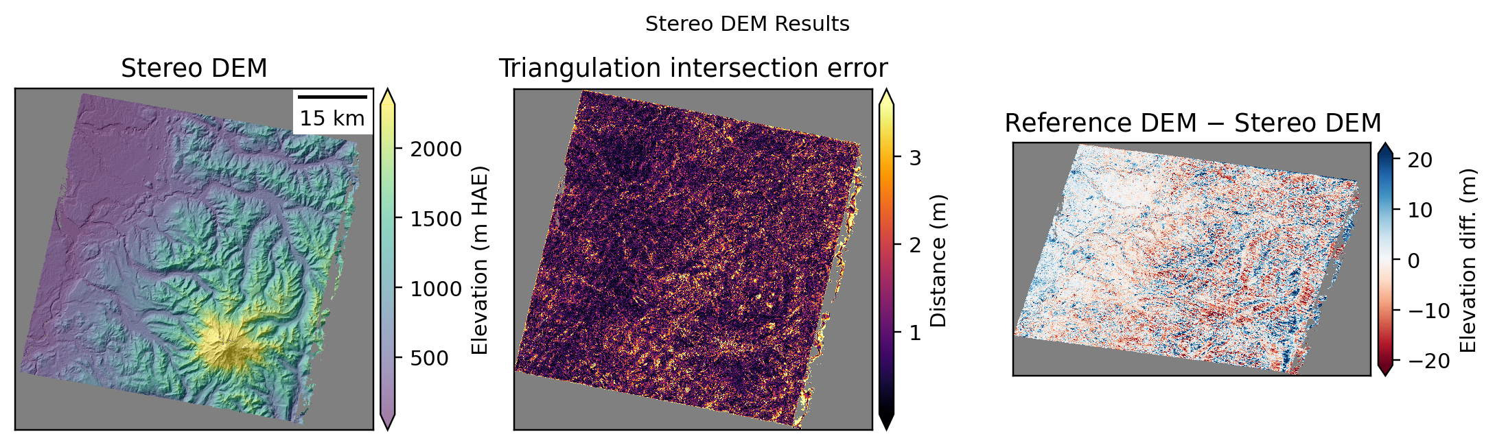
plotter.title = "Stereo DEM Results"

plotter.plot_dem_results()
WARNING:asp_plot.utils:Could not find ('*-align-L.txt',) in /Users/ben/Desktop/asp-plot-examples/aster_jitter/stereo_mgm_jitter_solved/. Some plots may be missing.
WARNING:asp_plot.utils:Could not find ('*-align-R.txt',) in /Users/ben/Desktop/asp-plot-examples/aster_jitter/stereo_mgm_jitter_solved/. Some plots may be missing.
Reference DEM: /Users/ben/Desktop/asp-plot-examples/aster_jitter/ref.tif


ASP DEM: /Users/ben/Desktop/asp-plot-examples/aster_jitter/stereo_mgm_jitter_solved/run-DEM_30m.tif

Plotting DEM results. This can take a minute for large inputs.
WARNING:asp_plot.stereo:

Found a DEM of difference: /Users/ben/Desktop/asp-plot-examples/aster_jitter/stereo_mgm_jitter_solved/run-DEM_30m_ref_diff.tif.
Using that for difference map plotting.
ICESat-2 Altimetry Validation#
import contextily as ctx
from asp_plot.altimetry import Altimetry
map_crs = "EPSG:32610"

ctx_kwargs = {
    "crs": map_crs,
    "source": ctx.providers.Esri.WorldImagery,
    "attribution_size": 0,
    "alpha": 0.5,
}
icesat = Altimetry(
  directory=directory,
  dem_fn=plotter.dem_fn
)
icesat.request_atl06sr_multi_processing(
    processing_levels=["all"],
    save_to_parquet=True,
)
WARNING:sliderule.sliderule:Warning, this environment is using an outdated client (v5.3.1). The code will run but some functionality supported by the server (v5.5.0) may not be available.
Time filter: 2018-10-14T00:00:00Z to 2026-07-30T00:00:00Z (all available)

ICESat-2 ATL06 request processing for: all
{'poly': [{'lon': -122.36648676044332, 'lat': 46.68467686575204}, {'lon': -122.36648676044332, 'lat': 47.363787417455434}, {'lon': -121.32622773402014, 'lat': 47.363787417455434}, {'lon': -121.32622773402014, 'lat': 46.68467686575204}, {'lon': -122.36648676044332, 'lat': 46.68467686575204}], 't0': '2018-10-14T00:00:00Z', 't1': '2026-07-30T00:00:00Z', 'res': 20, 'len': 40, 'ats': 20, 'fit': {'maxi': 6}, 'cnf': 'atl03_high', 'srt': -1, 'cnt': 10}
Existing file found, reading in: /Users/ben/Desktop/asp-plot-examples/aster_jitter/atl06sr_all.parquet
Parameters don't match request. Regenerating...
ERROR:sliderule.session:Alert <-7>: Failure on resource ATL03_20260514232946_09283106_007_01.h5 beam gt2l: H5Coro::Future read failure on gt2l/heights/dist_ph_along
ERROR:sliderule.session:Alert <-7>: Failure on resource ATL03_20250805003935_07682802_007_01.h5 beam gt3l: H5Coro::Future read failure on gt3l/heights/h_ph
ERROR:sliderule.session:Alert <-7>: Failure on resource ATL03_20230212195608_08291802_007_01.h5 beam gt1r: H5Coro::Future read failure on gt1r/heights/lon_ph
ERROR:sliderule.session:Alert <-7>: Failure on resource ATL03_20260504113849_07683102_007_01.h5 beam gt3l: H5Coro::Future read failure on gt3l/heights/dist_ph_across
ERROR:sliderule.session:Alert <-7>: Failure on resource ATL03_20210622125215_13701106_007_01.h5 beam gt2r: H5Coro::Future read failure on gt2r/heights/signal_conf_ph
ERROR:sliderule.session:Alert <-7>: Failure on resource ATL03_20221012014837_03261702_007_01.h5 beam gt2l: H5Coro::Future read failure on gt2l/heights/lon_ph
ERROR:sliderule.session:Alert <-7>: Failure on resource ATL03_20221012014837_03261702_007_01.h5 beam gt3l: H5Coro::Future read failure on gt3l/heights/dist_ph_across
ERROR:sliderule.session:Alert <-7>: Failure on resource ATL03_20240321130043_00442306_007_01.h5 beam gt2r: H5Coro::Future read failure on gt2r/heights/dist_ph_along
ERROR:sliderule.session:Alert <-7>: Failure on resource ATL03_20240321130043_00442306_007_01.h5 beam gt3r: H5Coro::Future read failure on gt3r/heights/h_ph
ERROR:sliderule.session:Alert <-7>: Failure on resource ATL03_20200318223358_12710602_007_01.h5 beam gt2r: H5Coro::Future read failure on gt2r/geolocation/segment_dist_x
ERROR:sliderule.session:Alert <-7>: Failure on resource ATL03_20260108171418_03873002_007_01.h5 beam gt2r: H5Coro::Future read failure on gt2r/heights/dist_ph_along
ERROR:sliderule.session:Alert <-7>: Failure on resource ATL03_20240321130043_00442306_007_01.h5 beam gt3l: H5Coro::Future read failure on gt3l/heights/dist_ph_along
ERROR:sliderule.session:Alert <-7>: Failure on resource ATL03_20210524141613_09281106_007_01.h5 beam gt2l: H5Coro::Future read failure on gt2l/heights/quality_ph
ERROR:sliderule.session:Alert <-7>: Failure on resource ATL03_20240317130904_13702206_007_01.h5 beam gt3r: H5Coro::Future read failure on gt3r/heights/lat_ph
ERROR:sliderule.session:Alert <-7>: Failure on resource ATL03_20240317130904_13702206_007_01.h5 beam gt1r: H5Coro::Future read failure on gt1r/heights/delta_time
ERROR:sliderule.session:Alert <-7>: Failure on resource ATL03_20240317130904_13702206_007_01.h5 beam gt1l: H5Coro::Future read failure on gt1l/geolocation/solar_elevation
ERROR:sliderule.session:Alert <-7>: Failure on resource ATL03_20200318223358_12710602_007_01.h5 beam gt3r: H5Coro::Future read failure on gt3r/heights/signal_conf_ph
ERROR:sliderule.session:Alert <-7>: Failure on resource ATL03_20200318223358_12710602_007_01.h5 beam gt3l: H5Coro::Future read failure on gt3l/heights/dist_ph_along
Sampling ESA WorldCover for 1032616 points (1 tile(s))...
WorldCover: 1032616/1032616 points sampled
Filtering ATL06-SR all
icesat.filter_esa_worldcover(filter_out="water")
No temporal filtering needed for the simplified report workflow. Advanced temporal filtering is still available via notebook/script method calls.
# Map view
icesat.mapview_plot_atl06sr_to_dem(
    key="all",
    map_crs=map_crs,
    **ctx_kwargs,
)

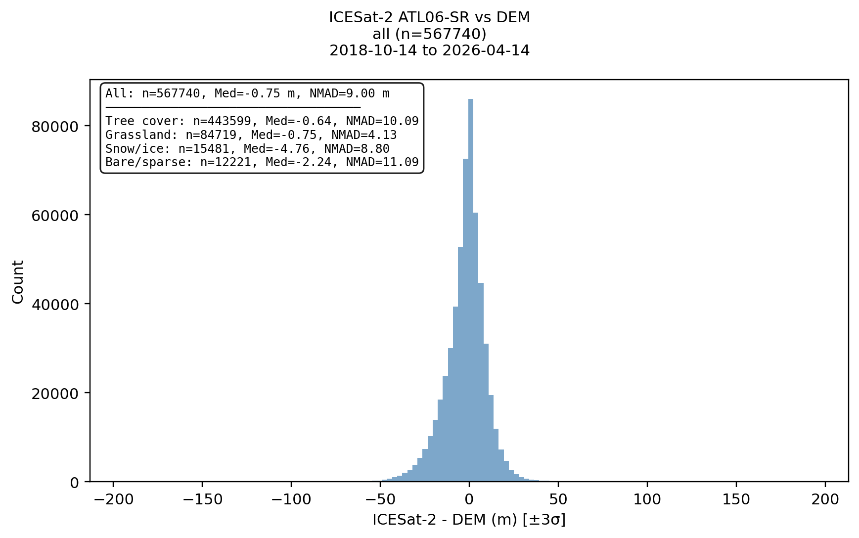
# Histogram with per-landcover-class statistics
icesat.histogram_by_landcover(key="all")

# Profile along the best ICESat-2 track
icesat.plot_atl06sr_dem_profile(key="all")
icesat.plot_best_worst_segments(key="all")
icesat_minus_dem not found in ATL06 dataframe: all. Running differencing first.
Outlier filter (3σ): all 955272 → 937729 (removed 17543)


Compare with NO Jitter Solving#
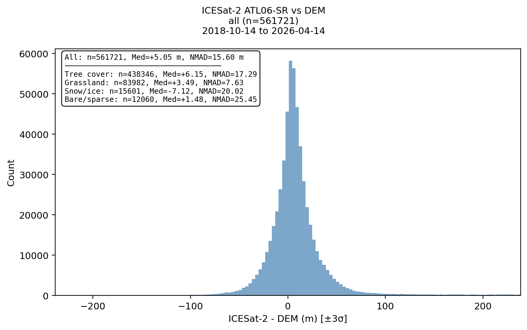
For reference, here is the ICESat histogram result for the same area with mapprojection but no jitter solving step. Note the reduction in Medium and NMAD with jitter solving applied:
Jitter Solve#
No Jitter Solve#